Steep Holm
Posted by
Unknown
at
8:45 AM

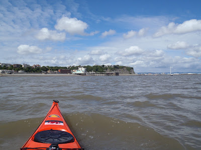
At the edge of the slipway I look out across the 6nm (11km) past Flat Holm to Steep Holm. The water was glassy and calm. Ive wanted to get to Steep Holm for ages having been to Flat Holm many times previously.

I left two hours before the start of the flood tide to allow plenty of time to get to my destination. After a quick 40mins I was at Flat Holm. I didnt plan on landing on Flat Holm but my bladder thought differently. Forecast came through on the VHF "possible force 7 gales later", hopefully "later" Ill be at home with a cup of tea!

Paddling to the far east side of Flat Holm my destination comes into view 2nm (3.7km) ahead. I felt a little apprehensive... will I be dragged too far south with the current? what if a ship comes up this busy shipping lane? All these questions playing on my mind.

No need to worry though, half hour later I was at Steep Holm. Makes me think why I havent bothered to make this extra 2nm crossing previously. There was a slight race on the eastern side of Flat Holm but apart from that a completely smooth journey.

I land on the stony beach and with about forty minutes until the tide turns I have lunch. Sitting here I realise England is now a lot closer than home (obvious I know). I can clearly make out the pier, the big wheel and even windows on the buildings at Weston Super Mare.

I climb up on a rock just bellow this spooky old building and have lunch when I notice a RNLI life boat approaching. I walk down to the beach as a crew member swims ashore. He came to see if all was ok and if I was aware of the force 7 gale that was coming in soon.

With all the gates locked leading up the path on to the main part of the island I decide to leave not long after not to be caught out in a gale.

Looking back at Flat Holm

Western Super Mare
Steep Holm as its name suggests rises 70m above the sea. It has been occupied by 12th century monks, WWII soldiers and now is home to two wardens. As with Flat Holm the island is covered in various fortifications as part of a defensive chain of the Bristol Channel in the 1860s. Unfortunately I will have to leave any exploration until next time.

Rounding the southern end of the island I reach Rudder Rock, named as the parallel plates of rock resemble a rudder. Once again pictures like this dont do the size of these rocks justice.

Rounding the southern end of the island I reach Rudder Rock, named as the parallel plates of rock resemble a rudder. Once again pictures like this dont do the size of these rocks justice.

Around Rudder Rock and I can just make out the stadium and tall city buildings of Cardiff beyond Flat Holm.

Looking back at the steep cliffs with the second largest tide mark in the world.

The shipping buoys between the two islands remind you to look out for these!

Once again in line with Flat Holm I am quite far south of the island. As I left slightly early the tide took me slightly south which isnt a big deal because itll soon pick up in the next hour of paddling taking my back north toward Penarth.

I landed at Penarth after an hour and a quarter with the tide pretty much where I left it.

A total 13.18nm (24.5km) trip in perfect conditions, although perfect is starting to get boring if Im honest. That force 7 gale turned up today! (Monday). A brilliant trip and an achievement Ive left too long.

It was a trip to the park on top of the hill for Zakk and Connor before heading home for a well deserved rest.

Subscribe to:
Post Comments (Atom)


0 comments:
Post a Comment